


Watersports on Carlingford Lough
 |
 |
||||||||
|
|
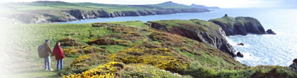
Beauty on the border
Watersports on Carlingford Lough Carlingford Lough is a stunning natural boudary between Northern Ireland and the Republic. Jeremy Taylor pays a visit The imposing shores of Carlingford Lough could have been carved from one of the great tales of Irish mythology. This region was the legendary haunt of giant Finn McCool, the setting of Ulster’s epic saga Tain Bo Cuailgne, the battlefield of wicked Queen Medb – and home of the mighty Brown Bull of Cooley! A place of rolling hills, woodland and mountains, the Cooley Peninisula in the Republic of Ireland is separated from Northern Ireland by Carlingford’s narrow stretch of water. Carlingford town is a former fishing port with a collection of mediaeval castles and narrow streets squeezed in between the foot of Sliabh Foy mountain and the water’s edge. The whitewashed houses are becoming popular as holiday homes, as city people discover the delights of the local scenery and a quieter life. "There’s a raw beauty to the mountains, stone walls and windy ridges that greet tourists who want to explore the region by bike or on foot" Search for holiday cottages in Co Louth ->  Fowey Cottages,
Fowey R12 - Whitsand Bay,
South Cornwall Prices
J36 - Chillaton,
Devon's River Country Prices
There are plenty of decent restaurants here. Ghan House serves modern Irish cuisine and ingredients from its own garden. The Anchor Bar masquerades as a grocery store from the street front but is also a bar serving excellent grub. Known as PJs, it has a fine collection of ‘authentic’ leprechaun bones on display to hoodwink unsuspecting tourists… Legend has it that St Patrick landed briefly here, en route to bringing Christianity to the country, while the Vikings were less welcome visitors. The ruins of King John’s Castle guard the southern entrance to the lough and are open to the public. The north side was protected by Greencastle Fort, now in ruins and on a more dramatic, isolated headland. Carlingford Adventure Centre is the best place to hire a dinghy, canoe or bicycle and explore the landscape further. The centre operates its own tours so you need to book early to be sure of getting equipment. The Cooley Peninsula lies to the south of the lough and to the east of the busy border post at Dundalk. There’s a raw beauty to the mountains, stone walls and windy ridges that greet tourists who want to explore the region by bike or on foot. As you drive in from Dundalk, don’t miss the Proleek Dolmen – a unique pile of finely balanced stones that has somehow survived the passage of time. Located behind the Ballymascanlon Hotel, it’s also bordered by a Bronze Age gallery grave. Omeath, about four miles up river from Carlingford, is a remote spot where Gaelic was spoken until quite recently. The main reasons for visiting are the music and the ferry to the picturesque seaside resort of Warrenpoint, on the Northern Ireland side of the lough. The town has all the usual tourist attractions, with plenty of restaurants and decent pubs. Dine at upmarket Aylesforte House, if you are feeling flush, or Bennett’s pub in Church Street for cheaper fare. It gets seriously busy only in August when the annual Maiden of the Mournes Festival takes place – a good-natured competition to find the most attractive local girl. A few miles up the road and past pretty Narrow Water Castle is Rostrevor. The town sits on the banks of the lough where it narrows dramatically and heads upstream towards Newry. Rostrevor has fine views across the water towards the Cooley Mountains – and a lively pub culture. The Fiddler’s Green Festival in the summer draws musicians from across the country. Good places to eat in the bustling centre include The Kilbroney Inn, famed for seafood, plus excellent home baking at The Healthy Choice Café. From Rostrevor it’s a short drive into the heart of the Mountains of Mourne, where you’ll find some of the best walking in the whole country. At 2,796ft, Slieve Donard is the highest peak in Ulster and, from its peak, Scotland and the Isle of Man are visible on most days. Go prepared: the weather can change quickly. For a less demanding walk, Donard Park has a network of paths through woodland and gardens at the foot of the hills. Want to know more?
Getting there
|
||||||||||||||
|
|
